
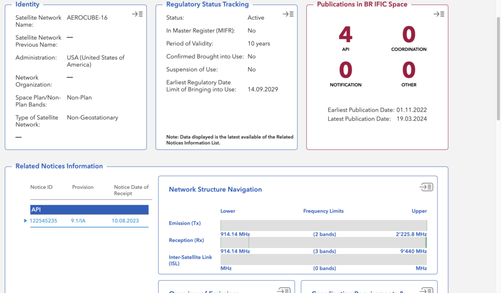
Source: ITU Space Explorer
Spectrum and orbital positions are unusual assets. A satellite operator cannot simply purchase them outright. Instead, their use is established through an international regulatory process: an administration submits a filing, the filing is dated and examined, other administrations may be asked to coordinate, and the resulting frequency assignments may eventually be recorded in an international register.
The record of this process is maintained by the International Telecommunication Union’s Radiocommunication Bureau. The ITU Space Explorer is the public-facing interface to that information. It is not a live satellite tracker, an operator directory, or a catalogue of spacecraft currently in orbit. It is better understood as a public ledger of international spectrum filings.
For investors, competitors, regulators, researchers, and journalists, the platform can answer important questions:
- Who submitted a satellite filing?
- Which frequencies and orbital characteristics were claimed?
- Under which regulatory procedure was the filing made?
- Has the filing progressed to notification and international recording?
- Which other administrations or satellite networks may be affected?
- Has the assignment been brought into use?
The difficulty is that the platform reflects the structure and language of the ITU Radio Regulations. A filing can be active without being operational, recorded without representing a fully deployed constellation, and associated with an administration that is not itself the satellite operator. Reading the database correctly therefore requires more than locating a network name.
What the ITU Space Explorer contains
The Space Explorer provides dashboard-based access to regulatory information concerning:
- geostationary and non-geostationary satellite networks;
- earth stations;
- radio astronomy stations;
- planned and non-planned frequency assignments;
- regulatory notices and publication histories;
- orbital and technical characteristics;
- coordination requirements and examination results.
The platform draws on two principal ITU data systems.
The Space Network System, or SNS, contains the technical and regulatory information submitted in satellite notices. This includes the particulars required under Appendix 4 of the Radio Regulations, such as frequencies, beams, emissions, orbital characteristics, and administrative information.
The Graphical Interference Management System, or GIMS, contains graphical material associated with filings. This can include service-area maps, antenna gain contours, beam diagrams, and other information used in interference analysis.
The platform replaced the former SNL Online and SNS Online applications in December 2024. Although the interface changed, the underlying regulatory concepts remain largely the same.
Space Explorer is updated in step with the publication of the BR International Frequency Information Circular, or BR IFIC. The circular is generally issued every two weeks. Consequently, information submitted after the most recent BR IFIC may not yet appear in the platform. For a rapidly developing satellite project, this delay can be significant.
A filing is not a satellite
The most important principle when using Space Explorer is that a database record represents a regulatory filing, not necessarily one physical spacecraft.
A satellite network filing can include:
- one or more orbital positions;
- hundreds or thousands of satellites;
- multiple frequency bands;
- transmitting and receiving beams;
- service areas;
- earth stations;
- antenna and power characteristics;
- several notices submitted at different regulatory stages.
One network name may therefore be associated with multiple notice records. An operator might submit one notice for advance publication, another for coordination, and another for notification. Each notice has its own identifier and procedural history.
Conversely, several physical satellites may operate successively under the same network filing. The regulatory network name may also differ from the spacecraft’s commercial or mission name.
For that reason, saying that an operator “has an ITU filing” provides very little information. The more useful questions are:
Which notice? Under which administration? For which frequencies? At what regulatory stage?
Decoding a Space Explorer
The URL of a dashboard reveals part of its regulatory structure. Consider the following example:
/networks-explorer/space-stations/dashboard/non-plans/AEROCUBE-16/122545235
Each section has a specific meaning.
Space stations
space-stations identifies the type of station being viewed.
The other principal categories are:
- earth stations;
- radio astronomy stations.
In ITU terminology, a “space station” is a station located on an object beyond, intended to go beyond, or that has been beyond the major portion of Earth’s atmosphere. It does not mean a crewed orbital facility.
Non-plans
non-plans identifies the regulatory regime.
Satellite spectrum is divided broadly into planned and non-planned frequency bands.
Planned bands are governed principally by Appendices 30, 30A, and 30B of the Radio Regulations. These appendices establish international plans intended to preserve equitable access to certain orbital and spectrum resources.
Non-planned bands operate through filing, examination, coordination, and notification procedures. Regulatory priority is strongly influenced by filing dates and by relationships with earlier networks.
This distinction is fundamental because it determines which procedures, protections, and deadlines apply.
Network name
AEROCUBE-16 is the satellite-network name submitted by the notifying administration.
The name is a regulatory label. It is not necessarily unique, and it does not itself create legal rights.
Notice ID
122545235 is the notice identifier.
This is often more important than the network name because a network can accumulate several notices during its lifetime. The notice ID identifies the specific submission being examined.
The notifying administration and the operator
Satellite filings are formally submitted by an ITU Member State, referred to as the notifying administration.
The administration is responsible for:
- communicating with the Radiocommunication Bureau;
- submitting the required information;
- responding to affected administrations;
- completing the applicable regulatory procedures;
- ensuring that operation remains consistent with the filing.
The notifying administration should not automatically be treated as the satellite operator. The actual operating organization may be:
- a private satellite company;
- a government agency;
- a university;
- a broadcaster;
- a research institution;
- another authorized body.
The operator’s identity may appear under fields such as operating agency or in due-diligence information. Some of this information may require authenticated access.
International registration is also distinct from national authorization. An ITU filing can establish international regulatory recognition, but the operator may still need national licences for its satellite service, earth stations, gateways, or user terminals.
Reading the dashboard structure
A Space Explorer dashboard presents the filing through a series of cards. The exact cards vary according to the type of network and regulatory procedure.
Network Structure Navigation
The Network Structure Navigation card shows the hierarchy of the filing.
A satellite network is not simply associated with one frequency. Its structure is generally organized as:
Network → beam → group → assignment
A beam represents an antenna coverage pattern or direction.
A group normally brings together assignments that share certain technical characteristics.
An assignment represents the use of a particular frequency under specified conditions.
One assignment may include:
- a frequency;
- an emission;
- bandwidth;
- polarization;
- power characteristics;
- antenna characteristics;
- a transmitting or receiving beam;
- a service area.
The Network Structure Navigation card is therefore the best starting point when determining how much spectrum the filing actually covers.
It may also provide access to:
- service-area maps;
- antenna gain contours;
- countries included in a service area;
- GIMS diagrams;
- individual frequency assignments.
Overview of Emission Characteristics
This card contains the technical substance of the spectrum claim.
Typical fields include:
- assigned frequency;
- necessary bandwidth;
- class of emission;
- modulation;
- polarization;
- maximum power;
- power spectral density;
- antenna gain;
- beam designation.
These characteristics determine both the intended communications performance and the interference that the network could cause to other systems.
A frequency range shown on a summary card does not necessarily mean that the network continuously occupies every frequency within that range. The range may summarize several individual assignments.
It is also important to check the direction of communication:
- Emission or Tx means the satellite transmits on the frequency.
- Reception or Rx means the satellite receives on the frequency.
- Inter-satellite link means the communication occurs between spacecraft.
Coordination Requirements and Examination Results
This is one of the most important cards for regulatory or commercial analysis.
The Radiocommunication Bureau examines a filing to determine whether it may affect previously filed or recorded systems. The dashboard may identify:
- affected administrations;
- affected satellite networks;
- frequency overlaps;
- applicable regulatory provisions;
- technical examination findings;
- requirements to obtain agreement.
An administration appearing on a coordination list should not automatically be described as experiencing harmful interference. Identification normally means that the filed parameters triggered a regulatory or technical threshold requiring further analysis or agreement.
Similarly, an unfavorable finding may apply only to:
- one frequency assignment;
- one beam;
- one service area;
- one regulatory provision.
It does not necessarily mean that the entire satellite network has been rejected.
From a diligence perspective, however, a filing that requires coordination with many earlier networks in a congested band may face greater technical, legal, and commercial uncertainty than a filing with few identified coordination requirements.
Publications and related notices
The publications section shows the regulatory history of the network.
Common notice categories include:
Advance Publication Information
Advance Publication Information, or API, alerts administrations to a proposed satellite system.
An API publication is an early regulatory step. It does not mean that coordination has been completed, that the assignments have been notified, or that the satellite has launched.
Coordination
A coordination notice begins or supports the process of reaching agreement with administrations whose assignments may be affected.
Not every satellite system follows exactly the same coordination procedure. The applicable requirements depend on the orbit, service, frequency band, and regulatory provision.
Notification
Notification is the stage at which frequency assignments are submitted for examination and possible recording in the Master International Frequency Register.
A notification notice is generally a more mature regulatory step than an API notice, but it must still be examined.
Other notices
Additional records may concern:
- amendments;
- corrections;
- cancellations;
- suppression;
- suspension;
- due diligence;
- bringing into use;
- changes to technical characteristics.
To understand a network’s history, the related notices should be read chronologically rather than treated as independent records.
Regulatory and operational status
One of the easiest mistakes is to confuse the status of the filing with the status of the spacecraft.
Active
An active record generally means that the filing remains active in the ITU database.
It does not necessarily mean that:
- the satellite has launched;
- the service is available;
- the complete constellation has been deployed;
- all frequency assignments are in use.
In the Master Register
The Master International Frequency Register, or MIFR, contains frequency assignments that have undergone notification and examination and have been recorded with an associated regulatory finding.
Recording gives an assignment internationally recognized regulatory status, subject to the provisions and findings attached to it.
However, “MIFR: yes” should not automatically be interpreted as meaning that every frequency, beam, or satellite described by the filing has been favorably recorded.
Bringing into use
Bringing into use means that a frequency assignment has begun genuine operation in accordance with the applicable regulatory requirements.
The bringing-into-use date is not necessarily the same as:
- the launch date;
- the date the satellite reached its operational orbit;
- the beginning of commercial service.
A spacecraft might launch before the relevant frequency assignment is brought into use, or it might begin limited regulatory operation before offering a full commercial service.
Suspension
A recorded assignment may temporarily cease operation. The administration may report a suspension and may have a limited period in which to bring the assignment back into use.
The absence of a recorded suspension does not prove that transmissions occur continuously.
Period of validity
A filing may include a stated or applicable operating period. This should not be interpreted as an unconditional guarantee of spectrum rights for that entire period.
Continued recognition may depend on:
- bringing the assignment into use;
- maintaining operation;
- satisfying deployment milestones;
- completing coordination;
- complying with examination findings.
Orbital information
For a non-geostationary system, the orbital card may show:
- number of satellites;
- number of orbital planes;
- satellites per plane;
- inclination;
- apogee;
- perigee;
- operating altitude;
- reference body.
The apogee is the highest point of the orbit, while the perigee is the lowest.
If the apogee and perigee are similar, the orbit is approximately circular. A large difference indicates a more elliptical orbit.
The satellite count normally represents the architecture submitted in the filing. It is not necessarily the number currently deployed.
This distinction is particularly important for mega-constellations. A filing for thousands of satellites may remain active even though only a fraction have been launched.
A worked example: AEROCUBE-16
The AEROCUBE-16 filing, notice 122545235, provides a useful example because it concerns a relatively modest low-Earth-orbit technology mission rather than a commercial mega-constellation.
The mission consists of two 6U CubeSats developed by The Aerospace Corporation. The spacecraft were intended to carry advanced materials experiments and a pair of optical communications payloads known as Flashlight.
The optical payload illustrates an important limit of Space Explorer: the ITU radio filing describes the mission’s radio-frequency links, not every communications technology onboard the spacecraft.
The register may therefore describe:
- telemetry;
- tracking;
- command;
- radio data downlinks.
It does not necessarily describe an optical inter-satellite link because that link does not use radio-frequency spectrum.
AEROCUBE-16 also illustrates the importance of the non-plans designation in the URL. The filing is being examined under the procedures applicable to non-planned spectrum rather than the broadcasting or fixed-satellite plans.
Short-duration missions and Resolution 32
Traditional satellite coordination procedures can take longer than the operational life of a CubeSat mission. Resolution 32 was developed to provide a simplified regulatory framework for qualifying short-duration non-geostationary systems.
According to the supplied notes, the regime applies to systems with no more than ten satellites and exempts qualifying missions from certain Article 9 coordination procedures.
Other features include:
- a defined period for administrations to comment on the API;
- notification after launch;
- a short deadline for notifying the system after bringing it into use.
The procedure is based on mission duration rather than simply the physical size of a satellite. A small spacecraft can still support a long-term or commercially significant service, while a larger spacecraft might operate only briefly.
Large constellations and Resolution 35
At the other end of the scale, Resolution 35 addresses the deployment of large non-geostationary constellations.
Its milestone framework is intended to prevent an administration from preserving spectrum rights for a very large paper constellation after deploying only a small number of satellites.
Where the resolution applies, operators must deploy specified proportions of their constellation within defined periods. If a milestone is missed, the recognized number of satellites may be reduced to match the level actually deployed.
When examining a constellation, the original filed satellite count should therefore be compared with:
- the Resolution 35 milestone status;
- the number recognized after milestone review;
- bringing-into-use information;
- external launch and deployment records.
Due diligence and Resolution 49
Due-diligence information is intended to demonstrate that a filing represents a genuine implementation project rather than a speculative reservation of spectrum and orbital resources.
The information may cover:
- the operating agency;
- satellite manufacturer;
- launch provider;
- spacecraft contract;
- expected deployment arrangements;
- implementation milestones.
Due diligence strengthens the evidence that a project is progressing, but it is not proof that a launch occurred or that the proposed system was fully deployed.
Planned satellite networks
Not every dashboard uses the non-planned regulatory framework.
A URL containing something like:
plans/AP30-30A/BRB00001/86550044
describes a planned network governed by Appendices 30 and 30A.
Appendix 30 covers the space-to-Earth broadcasting-satellite downlink. Appendix 30A covers the associated Earth-to-space feeder link used to send content from an uplink facility to the broadcasting satellite.
In simplified form:
Feeder-link earth station → broadcasting satellite → receiving dishes or viewers
These records normally concern geostationary broadcasting systems and must be read using concepts such as the Plan, the List, Article 4, and Article 5.
The Plan and the List
The Plan is the internationally agreed baseline allocation of orbital positions and frequency assignments to administrations.
Its purpose is to preserve equitable access, particularly for broadcasting requirements, rather than allowing all resources to be captured solely through first-come, first-served filing.
The List contains certain assignments produced by modifications or additions that have successfully completed the applicable procedure.
A useful simplification is:
- Plan: the original internationally agreed assignment.
- List: an accepted modification or additional assignment.
Article 4 and Article 5
For planned networks, Article 4 and Article 5 serve different purposes.
Article 4 concerns modifications to the Plan and agreement-seeking procedures involving administrations whose assignments may be affected.
This is where the Bureau identifies potentially affected networks and where the proposing administration may need to obtain agreement.
Article 5 concerns notification, examination, and recording after the relevant planning and agreement requirements have been addressed.
Broadly:
Article 4 establishes or modifies the planned regulatory position.
Article 5 supports notification and recording for operation.
Orbital position and service area
A planned geostationary record normally includes a nominal longitude, such as 30° W.
This indicates the regulatory position on the geostationary arc. It is not a live satellite coordinate. An operating spacecraft will move within an authorized station-keeping region around that longitude.
The record may also define a service area, meaning the territory in which the broadcasting service is intended to be received.
The service area should not be confused with the entire physical footprint of the radio signal. Energy can extend outside the intended service area, but regulatory calculations are based on the filed beam and service characteristics.
Beams, test points, and antenna patterns
A beam is the geographical pattern produced by a satellite antenna.
Each beam may have its own:
- service area;
- gain pattern;
- polarization;
- frequencies;
- power levels.
Planned broadcasting systems may also use test points. These are specified geographic locations used in technical calculations.
The ITU can use test points to assess:
- whether the intended signal level is available within a service area;
- whether another assignment causes excessive interference;
- whether a proposed modification satisfies the Plan’s protection criteria.
A test point is a calculation location, not necessarily a physical earth station.
EIRP, power flux density, and protection margin
Several technical terms appear frequently in planned-system examinations.
EIRP
Equivalent isotropically radiated power, or EIRP, combines transmitter power, feeder losses, and antenna gain.
In simplified form:
EIRP = transmitter power − feeder losses + antenna gain
It describes how powerful the transmission appears in the direction of the beam.
Power flux density
Power flux density, or p.f.d., is the amount of radio power arriving per unit area at a location.
It is used to assess:
- received signal levels;
- interference;
- compliance with regulatory limits.
Carrier-to-interference ratio
The carrier-to-interference ratio, or C/I, compares the wanted signal with unwanted interference.
A higher C/I normally indicates a cleaner communications link.
Protection margin
The protection margin shows how a calculated result compares with the applicable protection criterion.
Typically:
- a positive margin indicates that the criterion is satisfied;
- a negative margin indicates a possible incompatibility or need for agreement.
The exact sign convention should nevertheless be confirmed in the relevant dashboard or examination output.
Special Sections and the BR IFIC
A Special Section is an official publication within the BR IFIC concerning a particular filing or procedural step.
It may publish information about:
- a proposed modification;
- affected assignments;
- examination results;
- requests for agreement;
- completed regulatory action.
The BR IFIC number and publication date help establish when the information formally entered the international regulatory process.
The date of publication should not be confused with the date of launch or bringing into use.
Access limitations
The Space Explorer’s lists and summary dashboards are publicly accessible. More detailed information about individual notices may require authenticated access.
ITU members and eligible organizations may use a TIES account. Other users may need a paid subscription to obtain detailed SNS information.
This access distinction matters because the public dashboard may show that emissions or assignments exist while withholding some of the detailed technical parameters required for a full engineering analysis.
A blank card or “no information” message should therefore not automatically be interpreted as meaning that no technical data were submitted.
A practical method for analysing a filing
A Space Explorer record can be evaluated in five stages.
1. Establish identity
Record:
- network name;
- notice ID;
- notifying administration;
- operating agency, where available;
- GSO or non-GSO status;
- planned or non-planned regime.
2. Determine regulatory maturity
Identify whether the record shows:
- advance publication;
- coordination;
- notification;
- MIFR recording;
- confirmed bringing into use;
- suspension;
- milestone compliance.
3. Define the technical scope
Identify:
- frequencies;
- transmission direction;
- services;
- number of satellites;
- orbit;
- beams;
- service areas;
- associated earth stations.
4. Assess coordination exposure
Examine:
- affected administrations;
- affected networks;
- applicable provisions;
- unfavorable findings;
- agreement requirements;
- congested frequency bands.
5. Look for implementation evidence
Compare:
- due-diligence information;
- bringing-into-use status;
- Resolution 35 milestones;
- notification history;
- recent BR IFIC publications.
External information may still be needed to determine how many satellites are currently in orbit or whether a commercial service is operating.
Reading the register honestly
Four cautions should guide every Space Explorer analysis.
A filing is not an operation
The existence of a record proves that regulatory information was submitted. It does not prove that a satellite is currently transmitting.
The administration is not necessarily the operator
States file with the ITU on behalf of operators. The commercial or institutional relationship between them must be established separately.
International recognition is not a national licence
Recording in the international system does not eliminate the need for domestic authorizations.
Search results are evidence, not an oracle
Complex combinations of filters can produce incomplete or unexpected results. Important conclusions should be checked against the individual notice, its related filings, applicable Radio Regulations, and other primary evidence.
Conclusion
The ITU Space Explorer is best understood as a regulatory lifecycle database.
It tracks a progression that can include:
proposal → publication → coordination → notification → recording → bringing into use → continued compliance
Its real value lies not in showing that a network name exists, but in revealing the substance and maturity of the associated spectrum claim.
A careful reader can use the platform to determine who filed, what was claimed, which rulebook applies, how the filing was examined, what coordination remains outstanding, and whether the assignments have moved from a regulatory proposal toward genuine operation.
The central distinction is that the dashboard describes international spectrum rights and obligations, not merely the engineering characteristics of a spacecraft. A useful reading order is therefore identity, regulatory framework, filing history, operational status, spectrum, coordination, and recording.